An Overview of the Region
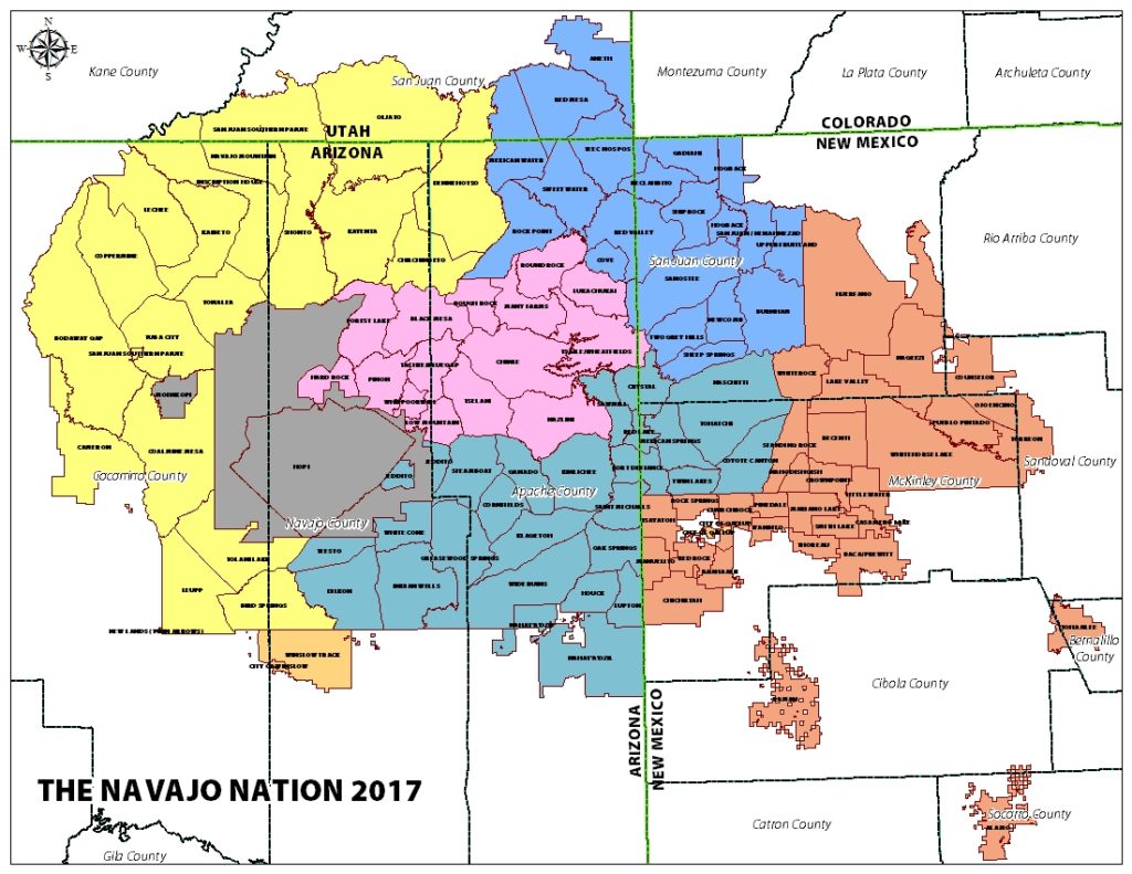
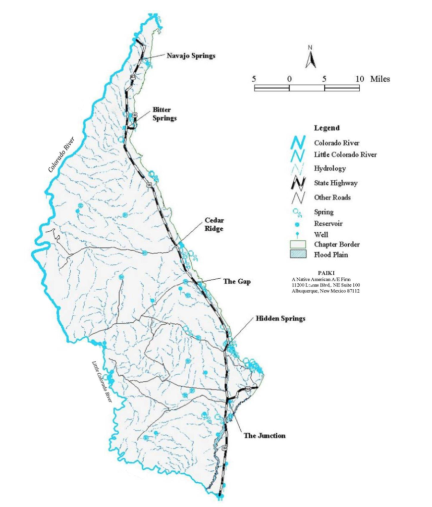
The Bodaway-Gap Chapter lies on the Western region of the Navajo Nation (as pictured below on the map). The Chapter’s Western edge is bordered by the Colorado River and the Little Colorado River moving South. The region has been given the name, “Tsinaabaas Hibitiin” by the Diné, translating to “inclined trail for wagons”. The Bodaway landscape is characterized by canyons, red rock cliffs, and sprawling desert (WH Pacific, 2008).
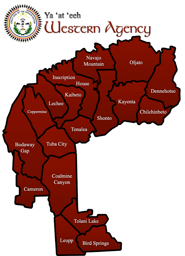
According to the 2010 U.S. Census, Bodaway has a population of 1,704 individuals, spread out among about 650 housing units (Bureau of Indian Affairs, 2016). The majority of residents live in the following six communities: Navajo Springs, Bitter Springs, Cedar Ridge, Hidden Springs, the Junction, and the Gap (WH Pacific, 2008). These communities are served by utilities that are provided along U.S. Highway 89, while residents living farther away do not have access to these services.
The Bureau of Indian Affairs commissioned Ecosystem Management Inc (an environmental consulting service) to conduct a survey of the usage of Diné land. They found that the most dominant use of land within the chapter is for animal grazing; 95% of the land is used as open space for cattle and sheep grazing, and ranch-keeping is the occupation of a significant portion of the chapter’s residents (Bureau of Indian Affairs, 2016).
History of the Region
In 1966, Robert Bennett, the commissioner of the Bureau of Indian Affairs, issued administrative orders that would prohibit the development of any lands in the Western portion of the Navajo Nation due to the disputes between the Diné and the Hopi. This dispute arose as a result of the United States government delineating boundaries of the Hopi Reservation, which excluded parts of sacred Hopi land. The resolution of this conflict through the Bennett Freeze Act was excruciatingly slow and resulted in substandard infrastructure and water system development in Bodaway. Though the Bennett Freeze Act has been lifted, there is still significant need for improvement in many areas including the development of water resources (WH Pacific, 2008).
Why Bodaway?
In the process of selecting our target case study region, we focused on areas already defined as subdivisions of the Navajo Nation. Our process put a heavy emphasis on selecting a chapter that combined a high population density and heavy concentration of contaminants in nearby water sources. Additionally we wanted to consider the impact of low numbers of water wells on large populations of users, in order to eventually extend solutions to many of the other regions across the Western Navajo Nation. Using these parameters and geographic imaging data, we decided to focus on Bodaway. Below is a map summarizing common pollutants across the Navajo Nation, and the circled portion marks a large contamination source near Bodaway.
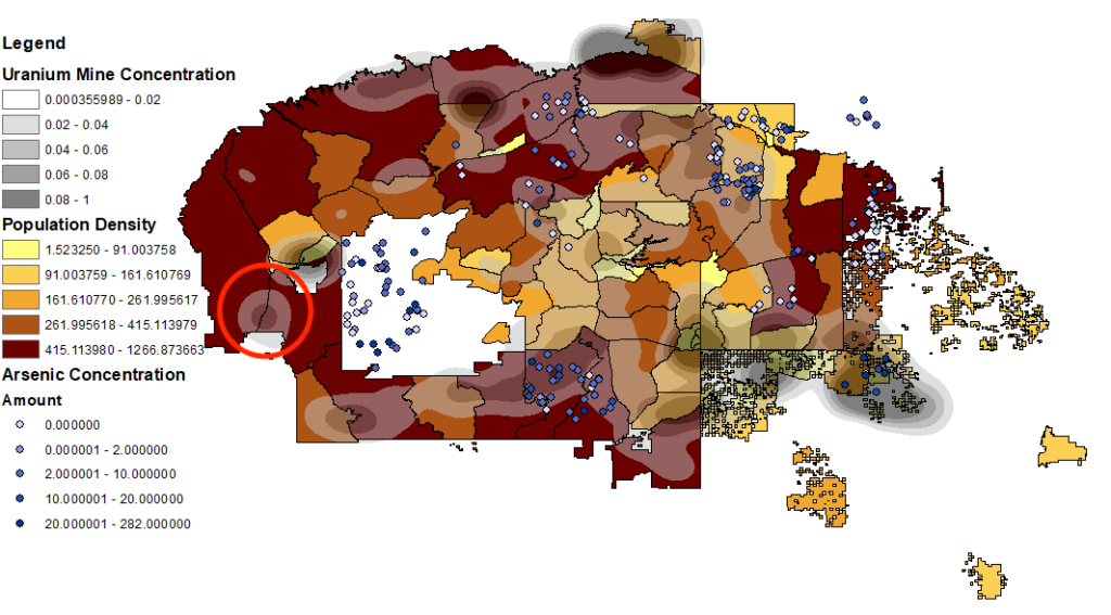
Map Generated in ArcGIS using data from the 2010 US Census and EPA Data
Specific Priorities Addressed in Bodaway
Water Access
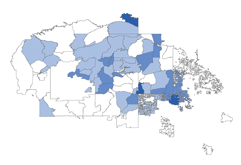
The shortage of usable water in the Bodaway chapter can be allocated to the depletion and contamination of its underground water sources. Locating over 2000ft above both the Little Colorado and Colorado rivers, and only a few stores selling bottled water, the choice of water for residents is ultimately limited to wells drawing from the underground water table. Unfortunately, the level of the water table in the Bodaway chapter has been dropping rapidly (Groundwater Surface-Water, 2013). Increases in agricultural and domestic water usage, combined with the increased frequency and severity of droughts due to global warming are two of the most direct factors contributing to water level dropping. As a consequence, many old wells are unable to reach the new effective water table. New wells need to be drilled. Overcoming the current shortage in water availbility will prove pivotal in providing aid to the Bodaway Gap Region. As seen on the Western side of the map below, the number of accessible wells is also diminishing in the Bodaway region.
Water Contamination
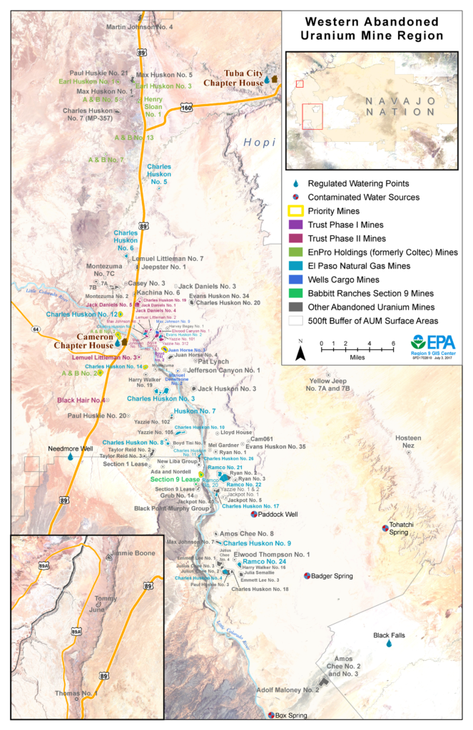
The Bodaway chapter contains many abandoned uranium and other heavy metal mines. Due to loose regulations, most mines were not operated with safety precautions (Gold King Mine 2015). As a result, underground water aquifers were severely contaminated with heavy metals. Two problematic heavy metals, uranium and arsenic, have been found in well water samples. To the right is a map depicting the major abandoned uranium mine sites, which contribute to the current contamination. Although there are other areas on the map that exemplify direr situations in regards to metal toxicity, Bodaway’s demographics and groundwater resources make it an ideal case study.
Jobs and Low Income
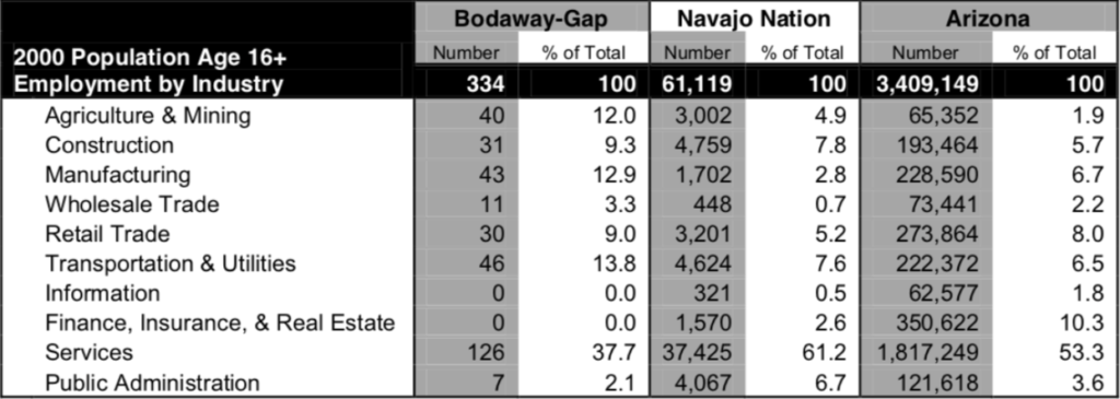
According to the table above, a large portion of jobs are heavily dependent on water resources including jobs in agriculture, services, and utilities. More than twice the percentage of people in the Bodaway Chapter rely on agriculture and mining for jobs in comparison to the Navajo Nation as a whole.
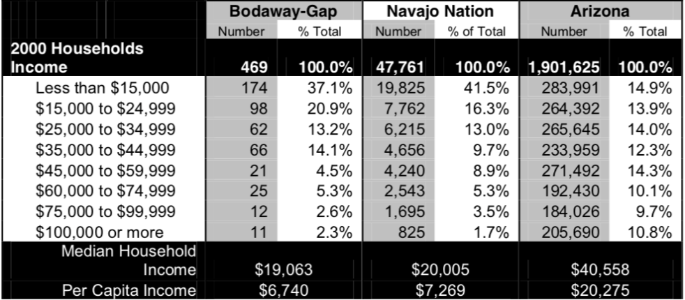
As can be seen from the table above, the Bodaway-Gap Chapter has comparable median household statistics to the entire Navajo Nation, but significantly lower statistics to that of Arizona. These lower numbers may be attributed to the fact that a good percentage of residents work in the informal sector (as ranchers and skilled craftsman) and hence their households is not well-documented. 45% households are below the poverty level. However, residents of Bitter Springs earn a higher median household income, $24,886, than the rest of the Chapter and the Navajo Nation. The implementation of filters and the proposed solutions requires maintenance and also innovators. This could provide more jobs and allow for community involvement (WH Pacific, 2008).
Current Water Systems
The water systems for the Bodaway-Gap region are currently split among its six major communities. In Northern Bodaway, the Navajo Springs community does not have any wells because the area is unsuitable for drilling (Bodaway Gap Chapter). Instead, the Indian Health Services brought water to the area through waterlines built in 2003 (WH Pacific, 2008). In the South, the Bitter Springs area has three wells which draw water from the C-aquifer and the Moenkopi Plateau. The C-aquifer is one of the largest aquifer systems supplying the Northern Arizona region (USGS, 2012). Residents of Cedar Ridge have access to two communal wells, while those in Hidden Springs have their own private well systems. The Gap community uses two wells and pipes water to Bitter Springs and Navajo Springs. Lastly, the Junction has access to one well (WH Pacific, 2008).
Conceptual Implementation
Based on the geography and demographics of Bodaway, we have decided that AER filtration systems, groundwater wells, and water storage systems could be used in conjunction with existing storage tanks to provide potable water to communities. We propose that 3 AER filtration systems could supply water to the majority of the region of Bodaway. Bodaway can be divided into a northern region, central region, and southern region, so one filtration system could be implemented in the center of each of these three regions. Groundwater wells contaminated with uranium, arsenic, and biological contaminants could be pumped into the central AER filtration system, filtered, and then stored in large storage tanks. The filtered water can then be retrieved directly from the tanks or by water truck delivery. 3 water trucks could serve Bodaway, each delivering water to homes within their respective regions. Funding for water truck delivery teams could both provide an efficient transportation service (especially for the elderly or less mobile residents) and create job opportunities in the community. A pipeline system connected to the central filtration system could also be implemented to significantly increase water access. Biofiltration or KAF filters can be used for with water sources containing arsenic as another useful tool in addition to the AER filtration systems.

Learn More about Our Solutions
Legal Evaluation
The Navajo Nation owns all surface water, groundwater, and hydrologically enclosed systems on the Navajo Reservation. Therefore, members of the Navajo Nation cannot be charged for water obtained from the reservation. The Navajo Tribal Utility Authority, which operates water utilities for a large portion of the nation, charges customers a service charge for filtering and distributing water, and managing waste, but it does not charge for the water itself. The 1984 Water Code is the main source of water regulations and restrictions in the Navajo Nation (“Summary of Water Code Fees Taxes”, 2018).
The main impact of the Navajo Water Code is that at a household level, water procurement is lightly regulated and at a commercial scale. Withdrawals over 40,000 gallons per quarter require a water permit and are subject to fees; however, there are no fees for individual homes, government buildings, and buildings of the Navajo Tribal Utility Authority system (“Summary of Water Code Fees Taxes”, 2018). Therefore, usage of river water in this way is not only legal, but inexpensive.
Our analysis concludes that filter-based solutions can be implemented on existing water systems or systems of less than 440 gallons per day with few legal concerns. Larger systems, such as our proposed anion exchange resin system, may have to file for a permit and pay water fees, but this should not be a considerable hurdle. By partnering with local government, we could implement the system without significant legal obstacles or extreme costs. Biofiltering solutions such as bioswales bypass fees if used for agriculture or small scale filtering. Groundwater wells are legally viable if the appropriate well drilling permit and archeological clearances are procured. Household solutions, like rainwater collection systems, should be feasible due to the low water volume being collected and stored. The implementations of solutions discussed in “Conserving Water in Agriculture” are essentially subject to the discretion of farmers and don’t infringe on Environmental Protection Agency, Fish and Wildlife Service, or Water Code laws (“Laws & Regulations”, 2018). In sum, the solutions discussed for improving water security in the Navajo Nation are legally viable.